- 166 live players
- 64,229 square miles
- 6 states
- 40 congressional districts
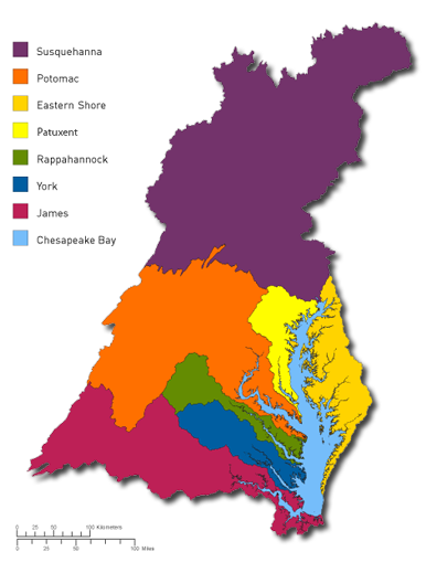
- 7 watersheds
About the Chesapeake Bay Watershed
Extending over six states and 64,000 square miles, the Bay watershed is impacted daily by a broad range of individuals, communities and industries that live and work in its boundaries. Representing the 27 million residents in the watershed, players in the Bay Game make decisions based on an assigned stakeholder role. Farmers make decisions about whether to leave land fallow or apply cover crops to their fields, for instance, and land developers decide between regular and sustainable development.
Chesapeake Bay Facts
- Formed about 12,000 years ago as glaciers melted and flooded the Susquehanna River valley, the Chesapeake Bay is North America's largest estuary (where fresh & salt water come together) and the world's third largest.
- "Chesapeake" derives from the Native American "Tschiswapeki," which loosely translates into "great shellfish bay."
- The Chesapeake Bay watershed is 64,000 square miles and has 11,600 miles of tidal shoreline – more than the entire US west coast!
- The watershed encompasses parts of six states - Delaware, Maryland, New York, Pennsylvania, Virginia, and West Virginia, as well as Washington D.C.
- The Bay holds more than 15 trillion gallons of water.
- Approximately 17 million people live in the watershed; about 10 million people live along its shores or near them.
- The Bay receives about half its water volume from the Atlantic Ocean. The rest drains into the Bay from an enormous 64,000-square-mile watershed.
- The average depth of the Bay, including tributaries, is about 21 feet.
- The deepest part of the Bay, "the Hole," is 174 feet deep and located off Bloody Point southeast of Annapolis, MD.
- The narrowest part of the Bay, near Aberdeen, MD, is about 3.5 miles.
- The widest point - from Smith Point, VA, to Virginia's Eastern Shore - is 30 miles.
- There are more than 100,000 streams, creeks, or rivers in the watershed, including 150 major rivers. One can reach a Bay tributary in less than 15 minutes from nearly everywhere in the watershed.
- More than 500 million pounds of seafood is harvested from the Bay every year.
- The Bay supports 3,600 species of plant and animal life, including more than 300 fish species and 2,700 plant types.
- The leading threat to the health of the Chesapeake Bay is excess nitrogen and phosphorus pollution that destroys habitat and causes fish kills. Top sources of these pollutants include agriculture, sewage treatment plants, runoff from urban and suburban areas, and air pollution from automobiles, factories, and power plants. Other threats to the Bay's health include sprawl, toxic pollution, and poor fishery management.
- A few deep troughs running along much of the Bay's length reach up to 174 feet in depth. These troughs are believed to be remnants of the ancient Susquehanna River. Two of the five major North Atlantic ports in the United States—Baltimore and Hampton Roads—are on the Bay.
- Everything we do on the land—including the use of automobiles, fertilizers, pesticides, toilets, water and electricity—affects our streams, rivers and the Bay.
Bay Resources
- The Chesapeake Bay Foundation
- Chesapeake EcoCheck
- Chesapeake Bay Program Maps and Resources
- Chesapeake Bay Interactive View (uses Google Earth)
- North America Watersheds Interactive View (uses Google Earth)
Copyright © 2008-2026 by the Rector and Visitors of the University of Virginia. All rights reserved.